

New York City Economic Development Corporation (NYCEDC) and the Mayor’s Office of Climate Resiliency (MOCR) released the financial district and seaport climate resilience master plan, a blueprint for comprehensive flood defense infrastructure to protect Lower Manhattan from the urgent threat of climate change. The plan, projected to cost $5 to $7 billion, reimagines the shoreline of Lower Manhattan to create a resilient waterfront capable of withstanding severe coastal storms and rising sea levels.
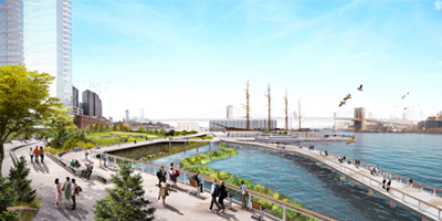
To protect the area, the master plan features a multi-level waterfront that extends the shoreline of the East River by up to 61 m (200 ft) from its existing location. The upper level will be elevated by about 4.5 to 5.4 m (15 to 18 ft) to protect against severe storms like Hurricane Sandy, while doubling as public open spaces with sweeping views of the city and harbor. The lower level will be a continuous waterfront esplanade while connecting New Yorkers to the water’s edge.
The master plan encompasses almost one mile of waterfront from The Battery to the Brooklyn Bridge. Notable features of the proposed plan include:
- Floodwalls buried in the landscape that create a line of ridges along this waterfront, permanently protecting Lower Manhattan from coastal storms and creating new open spaces with expansive views of the harbor;
- Resilient stormwater infrastructure, including a new pump station along with green infrastructure;
- Resilient ferry terminals for Staten Island, Governors Island, and NYC Ferries, among other operators;
- Universally accessible entrances and pathways, designed to ensure people of all ages and abilities can get to and move around the waterfront;
- New public open spaces with playgrounds, plazas, lawns, seating, and cafes;
- Coves that promote habitat restoration and provide opportunities to learn about the ecology of the East River; and
- Resilient piers for docking historic ships, bolstering the historic character of South Street Seaport.
Next year, the city will move forward with the next phase of design and engineering needed to apply for federal funding and obtain required permits from state and federal regulatory agencies. With funding and prioritization by the regulatory agencies, comprehensive flood protection could be in place by 2035.

