

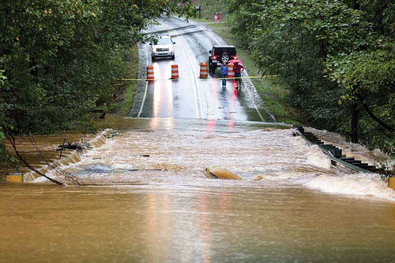
While FEMA maps can identify areas of potential concern, classification as a low or moderate FEMA flood risk zone is not the end of the evaluation process. It is still important to consider potential flooding associated with thunderstorms, hurricanes in coastal areas, nor’easters in the northeast region, tropical storms, and frontal storm events. Precipitation from these storms may exceed the capacity of the existing stormwater drainage system and result in flooding.
Undersized or inadequately maintained stormwater drainage can result in standing water and sheet flow flooding at depths of 0.3 to 0.9 m (1 to 3 ft), as rainfall flows across sloped land (i.e. pluvial flood). As urban and suburban expansion persists, the growing network of roads and impermeable surfaces, replacing natural or landscaped spaces, places additional strain on stormwater drainage systems.
The National Oceanic and Atmospheric Administration (NOAA) provides National Hurricane Center Storm Surge Risk Maps to project the potential for storm-related flooding of less than 0.9 m (3 ft), greater than 0.9 m (3 ft), greater than 1.8 m (6 ft), or greater than 2.7 m (9 ft) for given coastal areas. In addition, various cities and towns provide interactive mapping through their websites to simulate flooding from storms and/or sea level rise to assist in planning for the current and potential future flood risk exposure. For example, Boston Water and Sewer Commission (BWSC) provides an interactive model where the user can choose various rainfall and sea level rise inputs.2
Although these maps offer a useful initial reference, designers also need to consider the level of detail and the data sources employed in their creation when using the results for a specific location. For example, if a map has the flooding potential broken out by town or county, it may provide a skewed perception of risk at or near town lines where adjacent properties with similar risk appear to have more varied flooding potential. Depending on whether topography (and its level of detail) is incorporated into the mapping, properties at the top and bottom of a hill may appear to have the same flood potential. However, water will flow downhill and infill low points until it reaches an equilibrium point, meaning the property at the bottom of the hill may be underwater before the property at a higher elevation has cause for concern.
Flood emergency response plan
If flooding is determined to be a concern, the project team should assist the owner in developing a flood emergency response plan (FERP). This plan should include:
- Steps that need to be taken to provide protection during a potential flood event.
- Implementing a plan for monitoring weather well in advance of potential flood event.
- Designation of who will have the authority to decide whether or not to mobilize the selected flood mitigation system for a given event.
-
Typically, the first step in the flood mitigation process is assessing the flood risk for a given site. Determination of when the decision needs to be made based on system mobilization time(s). For example, sandbag systems, water-filled barrier systems, and anchored panel systems will all take various times to deploy based on length required, availability of water/material, storage distance and/or availability of workers.
- How to maintain access to the building (if needed) while the flood mitigation system is in place. This is typically accomplished by incorporating an access door in the system or providing bridging of the system.
- Steps that should be taken post-event as part of the recovery process.
- Procedures for familiarizing personnel with the system installation methods and regularly scheduled system condition checks, maintenance, and installation dry-runs.
Distributing this plan to the appropriate team and designating a responsible individual for each task are crucial steps to prevent any oversight in maintenance.

